
Robert Beazer – Produced in May of 2015
As I began work on our project with the Federal Highway Administration (FHWA), I was given subsets of their enterprise geodatabase that represented each of the wildlife reserves we would be working with. They also had a process they wanted us to follow to arrange the new geodatabases so the data we assembled would conform with the format of their geodatabase. This process was tedious and took some time to accomplish. Therefore, I decided it would be effortless to assemble a model that would perform the tasks, do it quickly, and the same way each and every time.
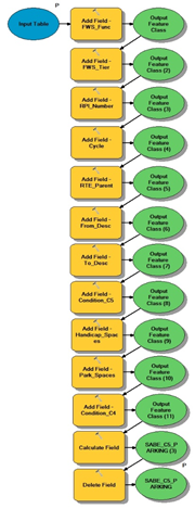
I created two models, one to perform operations on the parking area table and one for the route table. Each model had several steps to perform each one adding, deleting, or calculating fields in the new geodatabase. These steps were pretty simple to create but saved lots of time processing the final format of the geodatabase.